payton mcdonald pwnsqhnonjw unsplash 1

Pipeline Monitoring

Aerial Pipeline Network Monitoring

Raybird provides detailed monitoring of pipelines and surrounding infrastructure — both during routine inspections and emergency situations. It captures high-quality images, orthomosaics, and 3D models, and streams HD video in real time for rapid condition assessment. With its infrared payload, Raybird detects potential leaks invisible to the naked eye. Its long range and autonomy enable large-scale pipeline surveys without interruptions or additional logistics
litakind 1
bagatoformatna zyomka 1
Multiformat Imaging
Raybird simultaneously generates 2D orthomosaics, 3D models, and HD video — providing a complete aerial view of pipeline conditions, both wide-angle and in detail
vyyavlennya nevidimogo
Detection of the Invisible
Infrared sensors help detect potential leak points that cannot be identified with standard optics. This reduces the risk of accidents and losses
2500 1
High Autonomy
Up to 30 hours in the air and up to 2500 km range — Raybird can inspect long pipeline sections in a single flight
avtonomnist
Automated Inspections
Pre-programmed flight routes allow returning to the same sections to compare their condition over time — convenient for scheduled maintenance or post-repair inspection
pic 75x55sm 7 1

24-Hour Surveillance Without the Overtime Pay

Raybird can do everything helicopters and satellites offer in pipeline surveillance, like aerial imaging, route monitoring, and anomaly detection, but with greater precision, flexibility, and at a fraction of the cost. With over 24 hours of continuous flight time and omniweather capability, Raybird delivers uninterrupted situational awareness and control, even in harsh environments and remote areas

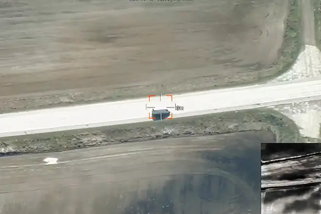
Unlike traditional methods that require large teams, ground vehicles, or manned aircraft, Raybird automates the inspection process. Equipped with advanced sensors, Raybird can detect leaks, corrosion, damage, and intrusions along hundreds of kilometers of pipeline. The system flies pre-programmed routes using GPS waypoints, gathers high-resolution imagery or video, and transmits data in real time or stores it for post-mission analysis

Its long endurance enables Raybird to monitor remote or hard-to-access areas in a single flight, cutting operational costs and improving safety by eliminating the need for human inspectors in hazardous environments. This makes it ideal for regular patrols, emergency assessments, and environmental monitoring

With Raybird, operators gain a cost-effective, autonomous, and scalable solution for maintaining pipeline integrity, minimizing risks, and responding faster to anomalies. It’s a powerful tool that meets today’s demands for efficiency, safety, and reliability in critical infrastructure monitoring

Footer (1)

Request Presentation


    group 1
    Privacy Overview

    This website uses cookies so that we can provide you with the best user experience possible. Cookie information is stored in your browser and performs functions such as recognising you when you return to our website and helping our team to understand which sections of the website you find most interesting and useful.